
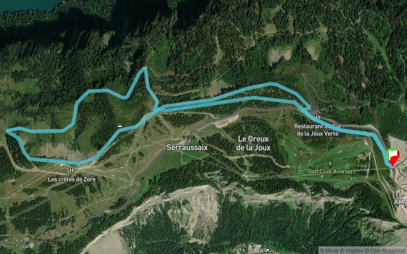
Circuit 50 vert - Avoriaz Joux Verte
ESPACE TRAIL ROUTE
 8.2 km
279 m
281 m
8.2 km
279 m
281 m

GPX
284
PDF
Profile
Share
3D
Favorites
Reviews
1 Like
Avoriaz (74) Avoriaz ()
Effort kilometer
Longest ascent
Longest descent
10
150 m
150 m
Max. elevation
Min. elevation
Quality index
1812 m
1626 m
 1pt/11m
You will start running down gradually to Joux Verte pass, then the track is a small hicking path to the Serraussaix ridge. You will go gradually to the Col de Croix. From there, turn around and take a downhill trail, through forests and landscapes. The track then is goign up to join Avoriaz.
Track created by Portes du Soleil Summer
le 2017/08/09 (modified on 2020/09/10)
le 2017/08/09 (modified on 2020/09/10)


Avoriaz
Distance
0 km
Altitude
1808 m
D+
0 m
D-
0 m
0.9 km
0 m
56 m
Col de la Joux Verte
Distance
0.9 km
Altitude
1755 m
D+
0 m
D-
56 m
2.4 km
35 m
48 m
Arête de Super Morzine
Distance
3.3 km
Altitude
1739 m
D+
35 m
D-
104 m
0.9 km
0 m
113 m
Nant de Lapiaz
Distance
4.2 km
Altitude
1629 m
D+
35 m
D-
217 m
1 km
71 m
9 m
Lac de Montriond
Distance
5.3 km
Altitude
1691 m
D+
106 m
D-
226 m
2.8 km
173 m
55 m
Finish
Distance
8.2 km
Altitude
1808 m
D+
279 m
D-
281 m
Avoriaz
Click on a point of interest to display it on the map
Reviews and times
Nicocot2019/08/13
2019/08/13 01:10:00
2019/08/13 01:10:00
Parcours agréable.
Indications correctes, mais il faut analyser le parcours avant de partir pour ne pas se tromper. Portions communes avec le parcours 13, mais indications parcours 50 manquantes parfois.
Add a track
Circuit 50 vert - Avoriaz Joux Verte

Track number : 42278
Link to track :
https://tracedetrail.fr/en/trace/42278
Log in to insert this track on your website
 Trace de Trail