Show the map
Notre-Dame de la Gorge - Mont Joly - Tête de la Combaz - Col du Joly - Col de la Fenêtre
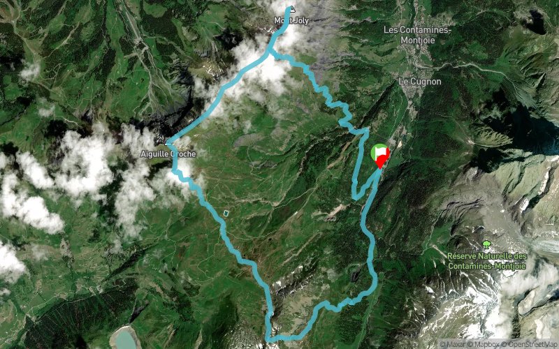


25.1 km
1880 m
1880 m
 Les Contamines-Montjoie (74)
 Points of Interest table
| Accum. | Intermediary | |||||||
|---|---|---|---|---|---|---|---|---|
| POI | Description | Alt. | Dist. | D+ | D- | Dist. | D+ | D- |
Trace n°38813
Ascent threshold : 3 m Distance threshold : 30 m Smoothing : Yes Origin of altitudes : MNT Aster GDEM
Ascent threshold : 3 m Distance threshold : 30 m Smoothing : Yes Origin of altitudes : MNT Aster GDEM
Loop
Dominant terrain : Footpath
Max alti. : 2506 m
Avg alti. : 1943 m
Min alti. : 1205 m
Longest ascent : 1320 m
Longest descent : 1020 m
Route completed by the author : nc
Dominant terrain : Footpath
Max alti. : 2506 m
Avg alti. : 1943 m
Min alti. : 1205 m
Longest ascent : 1320 m
Longest descent : 1020 m
Route completed by the author : nc
Elevation profile
More tools
Create a new roadbook page
Map and track on your website
Warning ! When you insert a Trace de Trail map on your website, you agree not to hide any element of the module (links to Trail Trail or Trail Connect banner)
Add a realisation
Validate
Add a realisation to share your chrono and describe the conditions that you encountered during you trail running !
Add a comment
Validate
jomand
12/06/18, 12:20:57
Bonjour, Vous évalué à combien le temps de cette sortie de 25km? Merci pour la trace, Baptiste
12/06/18, 12:20:57
Bonjour, Vous évalué à combien le temps de cette sortie de 25km? Merci pour la trace, Baptiste
Show the infos
Add a track


