Show the map
Brocey - Bois de Buissières - Le Tournoud - Les Gaudes
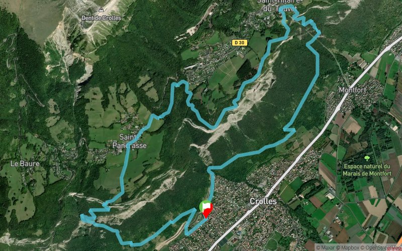


15.4 km
1110 m
1110 m
 Crolles (38)
 Points of Interest table
| Accum. | Intermediary | |||||||
|---|---|---|---|---|---|---|---|---|
| POI | Description | Alt. | Dist. | D+ | D- | Dist. | D+ | D- |
Trace n°50209
Ascent threshold : 3 m Distance threshold : 30 m Smoothing : Yes Origin of altitudes : MNT Aster GDEM
Ascent threshold : 3 m Distance threshold : 30 m Smoothing : Yes Origin of altitudes : MNT Aster GDEM
Loop
Dominant terrain : Path
Max alti. : 1058 m
Avg alti. : 659 m
Min alti. : 258 m
Longest ascent : 970 m
Longest descent : 690 m
Route completed by the author : nc
Dominant terrain : Path
Max alti. : 1058 m
Avg alti. : 659 m
Min alti. : 258 m
Longest ascent : 970 m
Longest descent : 690 m
Route completed by the author : nc
Elevation profile
More tools
Create a new roadbook page
Map and track on your website
Warning ! When you insert a Trace de Trail map on your website, you agree not to hide any element of the module (links to Trail Trail or Trail Connect banner)
Add a realisation
Validate
Add a realisation to share your chrono and describe the conditions that you encountered during you trail running !
Add a comment
Validate
Admin - Trace de Trail
07/01/18, 18:41:11
Bonjour, N'hésitez pas à utiliser le champ description pour décrire votre trace plutôt que les commentaires. Merci !
07/01/18, 18:41:11
Bonjour, N'hésitez pas à utiliser le champ description pour décrire votre trace plutôt que les commentaires. Merci !
Le_Taz
07/01/18, 17:44:53
Une sortie Montagne aux portes de Grenoble avec un bon D+ avec des sentiers parfois exposés
07/01/18, 17:44:53
Une sortie Montagne aux portes de Grenoble avec un bon D+ avec des sentiers parfois exposés
Show the infos
Add a track


